A
recent contract with LP Archaeology in the City of London raised some aspects
of recording worth some thought. The contract was an archaeological evaluation
on a site that straddled the projected line of the Roman, medieval and
post-medieval ditches that lie immediately outside the walls of Londinium and
London. Due to the expected depth of the archaeological deposits (geo-technical
boreholes showed up to 7.8m of potentially archaeological strata) the
evaluation strategy was for five 2.5m x 2.5m test pits that would be dug as
fully shored shafts. The test pits were located to give information on the
survival of archaeological strata, the nature of any such deposits, and the
potential survival of complex masonry and environmentally significant remains.
The pits were positioned across the site in an L-shape with three of the test
pits located to provide an east–west transect across the expected line of the
defensive ditches.
In
order to illustrate the excavated sequence it was decided to record a
representative section of each test pit, these could be used to construct an
illustrated section across the site which would illustrate the strata found in
the test pits, along with their conjectured extent. The impact of the proposed
development could be mapped against this to give an immediate visual
representation of the site. Unfortunately given the projected depth of the test
pits they would need to be close-shored with steel trench sheets and
timberwork. After the first metre or so of each pit had been dug and the shoring
had gone in, there would be little opportunity to view and record a traditional
section as due to the loose nature of the fill the trench sheets needed to be
dropped every 200-300mm to ensure the integrity of the shoring*.
 |
View of Test Pit 3 at approximately 7m depth
|
A traditional section drawing was recorded for the top 1.2m of each pit, and the section pins located on the top plan, however a different technique had to be used for the next few metres of the dig. The pits were excavated by hand and recorded using the MoL Single Context recording system, this involved drawing a 1:20 plan of each significant context, complete with levels, breaks of slope and hachures as appropriate. Every context had as a minimum a sketch plan with levels and measurements. The section could therefore be reconstructed from the plans as we dug: the extent of each context was simply mapped onto the section from the plan, with the relevant levels fixing the vertical height. Breaks of slopes could be similarly mapped onto the section drawing and the line of the slope added –joining the dots- as the context was being excavated. Cuts presented a slightly more complex situation, however a combination of the levels, planned extent, and the written description of the break of slopes, sides, and base, along with the sketched profile on the back of the context sheet meant that cuts too could be reconstructed with a good degree of accuracy.
Each context
was added to the section immediately after it was planned, which meant that the
section drawing could act as a quick reference on our progress, and highlighted
trends in the deposits –such as the transition from horizontal external
deposits to sloping levelling dumps reflecting the underlying slope of the
ditch sides.
 |
South facing section of Test Pit 1, reconstructed from plans
|
The final
sections, recording 7.8m of stratigraphy, provided a clear representation of
the strata, albeit slightly simplified. The individual test pit sections were
then scanned, digitised, and geo-referenced into a GIS project onto which
conjecture and the proposed development impact was added.
 |
South
facing section of Test Pit 3, the top 1.2m was drawn traditionally, the
remaining 6.6m reconstructed from plans and levels
|
The exercise
proved to be highly successful and was of great use on site, as well as
providing the basis for informative illustrations in the evaluation report. The
technique of reconstructing sections from plans raises wider issues about the
strengths of single context recording, and the need for accurate planning and
levelling.
One common
criticism of Single Context recording from rural archaeologists is that
sections are ‘never’ recorded. This is of course not true: Single Context
allows you to record as many sections as you like, wherever you like, the fact
is that many urban archaeologists choose not to ‘automatically’ section
everything because they prefer to dig stratigraphically rather than by section.
On complex archaeological sequences (and to be perfectly honest on simple ones
too) digging in plan is usually far more successful than knocking a slot or
section through an area and relying on the section to illustrate the sequence. You
allow the stratigraphy to work itself out, rather than imposing a pre-conceived
interpretation on the sequence and hoping you get the section in the right
place. Sections do of course have a fundamental place as part of the repertoire
of recording techniques, especially recording the interfaces between dynamic or
reworked contexts, however their use in an urban context is generally limited
for good reasons.
In
addition to the advantages of digging in plan, there is a further reason why
sections are not religiously used: the method outlined above can be used to
reconstruct a section between any two points on a site so you don’t need to
record sections as with proper recording they can be reconstructed along the
best line. Using the planned extents the horizontal extent of the context can
be fixed on any transect, the levels provide the vertical height value, and the
breaks of slope and hachures, along with the physical description and profile
drawing allow more complex cuts and interfaces to be recorded.
This
does of course rely on good recording, in particular it reinforces the need for
accurately located levels, and for the taking of sufficient levels to
illustrate the surface of any context. This is a Good Thing. A single level located on a plan should indicate that the surface of the
deposit is uniformly flat, whilst some deposits, cuts or structures may need
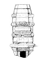
tens of levels to accurately allow the context to be properly recorded. The photo below is of the plan of a barrel vaulted structure, there was insufficient time
to draw a profile in addition to the plan before the trench was backfilled,
however it is possible to reconstruct a profile across the vault due to the
accurate planning and the correct distribution of levels.
 |
| Recording the barrel vault |
 |
Accurate plan of barrel vault with levels, enabling reconstruction of profile
|
Accurate
planning is essential for all archaeological recording methods, however in SC
recording it is additionally crucial that plans and levels are accurately
recorded as it is the superimposition of plans that demonstrates the
archaeological sequence via the plan matrix, and hence the creation of the
stratigraphic matrix. Accurate planning and levelling, whether on permatrace or
a measured sketch, can also allow any mistakes in excavation to be corrected:
if you dig a context out of sequence, or overdig it, then as long as you have
accurate plans/sketches and levels you can always get yourself out of the hole
you have dug. The use of ‘safety levels’ –additional levels taken in case the
original extent of a context is incorrect- is another way of making sure that
the true plan can be reconstructed should the context not pan out as originally
thought.
A
related issue is that of the nature of the interface between contexts, for a
few years my interest in recording systems has led me to feel that the generic MoLAS-derived
context sheet can be improved by a few simple additions. A key missing prompt
is, I believe, to record the interfaces between contexts, and the nature of the
surface of the context. This prompt exist on some company’s context sheets,
such as Cotswold Archaeology, however it should be added to everyone’s sheets
in my view! The nature of the surface and the interface between contexts –is it
trampled, is it diffuse- is essential part of the record and a key way of
understanding a sequence and the formation processes at play. In the 1980s the
Inner London Archaeological Unit used a variant of SC recording where each
deposit was given two context numbers: one for the surface of the context, and
one for the ‘body’ of the context. It may be over-recording, however it did
work in highlighting the need to record the interface between contexts. The
need for, and use of, prompts on context sheets is probably worth a separate
essay, but without specific prompting many archaeologists forget to properly
record contexts, and the nature of interfaces between contexts is one area that
is consistently under-recorded.
The
creation of reconstructed sections is one method in the archaeological toolkit,
and a very useful one when your section proves to be in the wrong place, but it
also underlines why proper accurate recording is so important if we are truly
to preserve by record, and how all the different elements of the drawn and
written record work together to create a true record of both each context, and
the entire site.
*It is
of course possible to create a running section of the exposed 2–300mm of
section as work progresses, however this can be time-consuming as you need to
constantly set up new string lines. It is certainly more accurate and allows
details of the inclusions to be recorded in detail, and is probably the better
method if the sequence is of complex structural remains such as clay and timber
buildings. In this instance the expected nature of the deposits: levelling
dumps, tips of refuse and external soils, meant that the reconstructed section
was a suitable form of record and accurate enough to reconstruct these ‘bulk’
deposits. As with all decisions about the suitable level of recording there are
alternatives, there is not a simple solution that is always correct. The
important thing is to always think about what you are recording, how you are
recording it, what the record will be potentially used for, and then to make an
informed decision.


No comments:
Post a Comment